

The U.S. Border Patrol agent was positioned behind a rust-colored vehicle barrier, on the other side of the international boundary line. He stopped when he saw me, bent down and taking a picture of grass. I was examining a tuft of sacaton, one of the several varieties of native grasses brought back to life by one of the largest ecological restoration projects on the U.S.-Mexico border, at the San Bernardino Ranch, located about 12 miles east of Agua Prieta/Douglas.
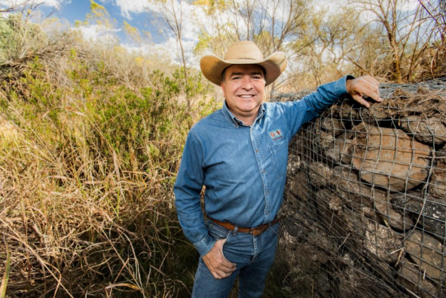
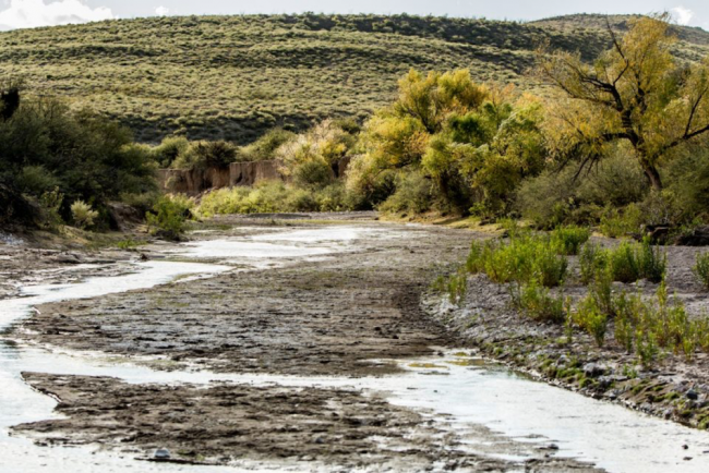
Juan Manuel Perez, dressed in jeans and a white cowboy hat, wasn’t fazed. Perez, who is originally from Chihuahua, is the foreman of the organization Cuenca Los Ojos (CLO) and in charge of 45,000 acres of restoration projects spread throughout the region. We walked away from the vehicle and into a nearby wash, called Silver Creek, where Perez showed me what was at the heart of Cuenca Los Ojos (which means “watershed of springs” in English) restoration on San Bernardino: an ancient technique of strategically piling rocks to slow down the flow of water across land. After years of mechanized farming, cattle production, and now drought, this once parched and barren landscape could begin to drink again—could again absorb this precious water.
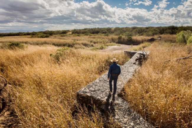
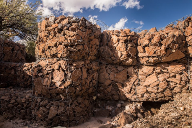
Since the 1990s, the restoration project has embedded galvanized wire cages, called gabions, on the banks and beds of washes. These gabions are filled to the brim with rocks and go as far as 18 feet deep into the ground. At first glance, they have the striking appearance of an intricate stone wall, a contrast to the border barrier just 100 yards away. But instead of keeping people out, they were built to be sponges shaped to the contour of the streambed and riverbank, slowing the water and replenishing the soil with life. Before they were built, rushing water from monsoon storms would take topsoil and leave cutting erosion. Now, there is water year-round.
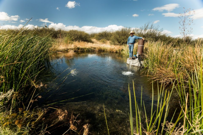
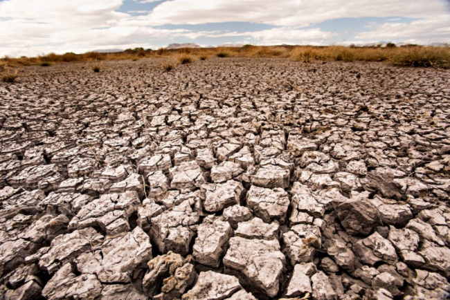
Perez gestured to the reviving landscape around him, to the 7,000 acres we could not see. It was not only what was on the surface—the native grasses and sprouting desert willows and cottonwoods—that was so remarkable. It was also what was below: a water table that had risen 30 feet in the middle of a brutal 15-year drought that everywhere else was sucking the land dry. All throughout the borderlands and Arizona, after years of hotter weather and less precipitation, the grass had withered, the earth had cracked, and the animals had died. Yet, water was recharging even 10 to 15 miles downstream from Rancho San Bernardino into Mexico, to places where people hadn’t seen it for decades. From brown to green, from completely dry to lush: to me, it seemed like a miracle.
As Perez and his CLO colleague David Hodges explained this, the Border Patrol agent backed his F-150 truck into the wash where he continued to keep an eye on us. This suspicion is only the most palpable tension between cross-border ecological restoration and one of the most militarized borders on the face of the earth. When sharing resources or doing measurements, what should be a five-minute walk to your neighbors turned into a 50-mile drive through a distant port of entry.
Both border militarization and ecological restoration are two distinct responses to the most challenging ecological crisis of our time: the changing climate. In this microcosm along a remote area of border, these two contrasting visions might just embody the future struggles of the world. As the Trump administration takes office with promises of hyper-racialized border building, you could say what I saw that day on this ranch was a tale of two walls—one about restoration, and the other about exclusion.
By the time you read this, 2016 will have been deemed the hottest year in historical record. Globally, the warmest 15 years have all occurred in the 2000s. The planet, according to 97 percent of scientists, is heating up due to human activity. The earth is on track to hit an average temperature increase of 6.3 degrees (3.5 degrees centigrade) by 2100—well above what has been deemed safe by scientists.
The desert borderlands of both the U.S. Southwest and the Mexican north are in the crosshairs of these climate cataclysms. “In apocalyptic visions of global climate change, the North American Southwest makes an easy protagonist,” wrote William deBuys in A Great Aridness, “the geographical equivalent of a stalled car on railroad tracks. Its aridity exposes it to shocks of all kinds.”
Indeed, the U.S.-Mexico borderlands are where the front lines of climate change collide with the front lines of border militarization. And with a climate denier at the helm of the United States—Trump has claimed that climate change is a “hoax” that originated from China—who has pledged to ramp up the border build-up, tensions are poised to sharpen considerably.
Alberto Teran is from the ejido 18 de Agosto, a small community of 29 families nine miles downstream from the restoration. Teran started working for Cuenca Los Ojos six years ago, piling the rocks in the galvanized wire cages of the gabions. Now he’s in charge of the agricultural projects—including the distribution of seeds of native grasses and the harvest of pistachio trees, among other things—on the ranch. When in 1976 Teran started farming in 18 de Agosto, it was dry. “We had very little water,” he says. They had to dig wells in the parched land, but it was difficult to get water they needed for harvest and animals. Because of this, when the CLO projects began, the community was dead-set against it, thinking, as Teran put it, “that the gabion dams were going to leave us without water.”
Almost all U.S. national security assessments indicated that water shortages, among other climate shocks, could propel mass migrations of people to the United States from places like 18 de Agosto. A 2003 Pentagon-commissioned report gave one of the first crude glimpses of how U.S. security officials were viewing future scenarios of climate cataclysms and massive displacements: “The United States and Australia are likely to build defensive fortresses around their countries because they have the resources and reserves to achieve self-sufficiency. Borders will be strengthened around the country to hold back unwanted starving immigrants from the Caribbean islands, Mexico, and South America.”
This report came out during the largest border enforcement build-up ever in the United States, one that started with operations in the 1990s, and accelerated in the post-9/11 era. Billions of dollars have pumped up an unprecedented enforcement and surveillance regime. The apparatus of border infrastructure includes almost 700 miles of walls and a network of surveillance cameras, motion sensors, radars, and drones run by the country’s largest federal law enforcement agency, U.S. Customs and Border Protection (CBP). The Border Patrol, a self-described paramilitary agency under CBP, has increased its ranks five-fold since the early 1990s. And now the tripartite mission of counterterrorism, immigration enforcement, and drug interdiction has accepted the vision of a future world made chaotic by climate change.
Yet, just across the line on the Mexican side, CLO and other restoration efforts are trying to create an entirely distinct future not only by restoring habitats, but also by supporting parched communities like 18 de Agosto. Much of this restoration work relies on the simplicity of strategically placed rock piles—in the case of CLO, 40,000 trincheras (smaller rock pile dams) and 50 gabion dams. At Silver Creek, the CLO’s David Hodges kept saying, with the cottonwoods taking hold throughout the area and the spread of native grasses—seven species have returned—that “we have passed the tipping point.” The wording struck me. In climate change literature, tipping points almost always refer to catastrophic points of no return: the ice sheets disintegrating, the violent super storms, the endless droughts. The tipping points here meant that the trees and grasses were not only growing back, they had also reached a point where they were doing it on their own.
For this restoration to happen, cross-border cooperation was essential. As Louise Misztal, the executive director of the Sky Island Alliance—another one of many organizations involved in cross-border restoration—said, “rivers, wildlife, and ecosystems do not recognize international borders.” Misztal said people on both sides of the divide were excited about the “unity building” needed for ecological restoration work. Sky Island Alliance has set up cross-border exchange programs pairing experts with students to fuel their projects. Yet the border apparatus is constantly inhibiting such work.
When, in 2008, Homeland Security bulldozers began to blade the border in front of Rancho San Beherdino to create a road and construct vehicle barriers, they cut through a migratory wildlife corridor. Valer Austin, originally an artist from New York and one of the founders of Cuenca Los Ojos, said that this type of border militarization was “impeding the flow of nature.” The blading not only impacted water flows and courses, the new road brought significant Homeland Security vehicle traffic, leaving a permanent indenture in the middle of an otherwise rising streambed full of new life and water, and cutting into the harvesting work of the gabions.
When the border security bulldozers blazed their path through the San Bernardino wildlife refuge, they did it without any consultation. DHS waived 37 environmental and cultural heritage laws to build the walls, barriers, and roads along the border, all in the name of national security. Once, a bulldozer toppled into a restoring wetland and wasn’t extracted for two days. There has been so much environmental destruction along the international divide—by not only the massive wall and barrier construction but also by Border Patrol four-wheel-drive trucks that have created roads by trampling thousands of miles of pristine and protected areas in places like Organ Pipe Cactus National Monument and Cabeza Prieta National Wildlife Refuge—that the Sierra Club formed a borderlands program to oppose and mitigate any further expansion.
In 2010, the United States declared climate change a top national security threat. In 2012 and 2014, DHS incorporated the “climate threat” into its mission with a climate adaptation plan and its quadrennial review. In these documents, DHS conveyed the possibility of potential upheavals in Mexico and Latin America due to climate change. Perhaps in the halls of the U.S. Congress—and in our Oval Office—there still is a debate about climate change, but in the halls of the military there are no such illusions. Homeland Security, which has been described as a “standing army on U.S. soil,” has stated directly the need to prepare U.S. borders for “more frequent, short-term, disaster-driven migration, such as mass migration.” There is no mention, however, of what might be a much more effective solution—cross-boundary ecological restoration.
When the water restoration project began in the late 1990s on the San Bernardino Ranch, the people of 18 de Agosto were dead-set against it. Who could blame them? Mexico had just entered the NAFTA era; the country’s natural resources were put up for sale to the highest bidder and the Mexican government was cutting subsidies and credit to small farmers like Teran. In fact, Teran told me that “it was impossible” to grow a crop like corn to sell profitably, saying, “We can’t compete.” Add to this the aridity of climate change, the drying out of water sources needed to grow the wheat the community had collectively farmed until the 1990s, and you had what sociologist Christian Parenti called the “catastrophic convergence” of political, economic, and ecological issues. Such a convergence often results in the displacement of people; this was the case in 18 de Agosto. The elementary and secondary schools were shut down in the 1990s. People began to leave, Teran’s four children included. Now one of his daughters lives in Agua Prieta and has low-wage work at a maquiladora, or factory. Another daughter is in Oklahoma.
As I stood again with Alberto Teran in the same place where the Border Patrol agent in the idling vehicle had eyed us months before, he spotted a flattened backpack and plastic bottle with condensed water droplets under a knotty mesquite tree. Someone had crossed the border, and not too long ago. As we walked toward Silver Creek and the gabions, Teran told me that in his community, several years ago, water started to appear in places it had never appeared before. He told me that the river began to run again year-round. He told me again that in the middle of the drought the water table in the San Bernardino Valley began to rise, while everywhere else they were depleting.
The drying up of the Mexican north has led many researchers to predict that people—perhaps thousands of people—would be on the move as a direct result of climate change. But the restoration project, Teran told me later as we stood in front of the running stream, “is benefiting us, not only there on the ranch San Bernardino, but here, 12 kilometers downstream.”
Now people in 18 de Agosto are expanding the restoration work, and have embedded gabions along the river. Teran told me they are thinking about irrigating the plot of farmland where they grow sorghum and alfalfa. There is still a lot of work to do, but now there is a trickle of hope. In this small area, a drought is being reversed.
Indeed, the very sound of the water passing behind Teran as he talked was a testament to the importance of cross-border restoration work as we advance further into a warming 21st century predicted to be fraught with upheavals. A rebounding watershed could not only revive habitat, it could also support sustenance agriculture for people like Teran and his children. If done on a large scale, the very thousands predicted to migrate to the United States might choose to stay in places like 18 de Agosto.
When Alberto Teran and I visited the gabions in Silver Creek four months later, I could see a newly erected surveillance tower, a tower equipped with radar and cameras with night vision and thermal energy capabilities. In 2014, CBP awarded the company Elbit Systems of America a contract to build 52 such towers across southern Arizona to the tune of almost $1 billion. The purpose of the tower was simply to do surveillance. It provided no water to 18 de Agosto, supported no new vegetation, offered no solution to the climate crisis.
In a conversation with Valer Austin, I asked her, given the success of the restoration at San Bernardino, what could CLO and other restoration groups in the borderlands do with the $19.5 billion designated to border and immigration enforcement each year? When she heard that number, she, like many others, said, “Oh, my God.” Then quickly, “That money could be put to better use.”
From the high-society of New York City’s Upper West Side, Austin came to Arizona in the early ‘80s with her husband, Josiah. They bought a ranch and began to revive the landscape by piling up thousands of small rock dam trincheras. After dazzling success, they expanded and eventually cofounded the foundation Cuenca Los Ojos.
Austin said that CLO had invested millions, much from her own family inheritance, in the restoration projects in the borderlands—most prominently San Bernardino—that have restored a big swath of flora and fauna, including the return of wildlife to an area with the largest diversity of bees in the world. “But what if you had 100 times that [money]? You would get a whole river system to run. It would expand like ripples out and out and out. It would touch people for miles on either side of this river.
“With that kind of money,” Austin said, referring again to the combined budgets of CBP and Immigration and Customs Enforcement, “we can restore a lot of streams that on the ground would alter climate change in the region. It would make a huge difference. It would change the economics [of the region]. It would change the health. It would change everything on the border.
“It would make all the difference between life and death.”
This piece was originally published by Edible Baja.
Todd Miller is a journalist based in Tucson and the author of Border Patrol Nation: Dispatches from the Front Lines of Homeland Security and the forthcoming book Storming the Wall: Climate Change, Migration, and Homeland Security.